Ariana Brezai – Applied Science, Year 2
Abstract
Landslides are a frequent threat in British Columbia. Their occurrence results in the degradation of natural habitats, loss of investment in forest roads, and puts human life at risk. Neglecting to properly deactivate resource roads can further increase this risk. This study aims to model two different deactivation techniques, full road fill pullback and the implementation of cross ditches, testing whether they function as intended as well as comparing their effectiveness. To conduct tests, a 1:100 scale model with a slope grade of approximately 30° was used. A rainfall of 15 minutes with a 50-year return period was simulated and displaced soil was then collected and weighed. It was found that both road deactivation techniques tested successfully decreased risk of slope failure. Based on the results in this paper, the implementation of cross ditches has a higher success rate than a full road fill pullback. Ultimately, the results of this paper indicate that the suggested road deactivation techniques adequately decrease landslide risk, and it is highly recommended that resource roads throughout British Columbia are properly deactivated.
Introduction
Slope stability is a crucial concern in British Columbia (BC) as a result of the province’s mountainous terrain and frequent rainfall (Westrek Geotechnical Services Ltd, 2024). A critical factor that has played a role in, and continues to affect, the integrity of BC slopes is the existence and expansion of resource roads which span over 600,000 kilometers in BC (Schwab & Geertsema, 2008). Resource roads are mainly used by industrial vehicles to access natural resources and are either managed using permits or maintained by the BC government (Ministry of Forests, 2024). However, issues surrounding slope stability arise when resource roads are improperly constructed and managed (Forest Practices Board, 2017). Negative environmental and economic impacts arise (Schwab & Geertsema, 2008) but more significantly, landslides put lives at risk. For example, on November 15, 2021, the Duffey Lake landslide took the lives of five individuals (Brend & Duncombe, 2022).
When paired with heavy rainfall, a recognized landslide catalyst (Jing, X. et al 2019), it is common for slope failure to begin at these poorly maintained resource roads due to the interruption of natural water flow and absorption (Borga et al., 2004). Of the 26 roads segments reviewed by the BC Forest Practices Board (2017), it was found that only seven fully met the professional practice standards outlined in chapter 69 of the Forest and Range Practices Act. Thus, it is essential for the stability and integrity of resource roads to be better managed and maintenance requirements enforced. Improper deactivation of resource roads is of particular interest when pinpointing areas where resource road neglection leads to landslide risk. As resource roads are left unused and, in most cases, unmaintained, they degenerate in a manner that compromises the integrity of the slope they are built on which is why proper deactivation is required (Forest Practices Board, 2017). It is common for companies which build and use these service roads to neglect to properly deactivate these roads because they are expensive to build, maintain and deactivate (Forest Practices Board, 2017).
To combat this issue, techniques for road deactivation, that can be carried out by volunteers, have been developed by groups such as Redd Fish Restoration Society. These techniques include recontouring of the road’s sharp edge through modified brush layers to reduce the angle of the slope (Redd Fish Restoration Society, 2023). This paper presents results from tests conducted on a resource road model at a scale of 1:100 to explore whether they function as intended as well as to compare their effectiveness. Slope failure can be observed through ridging of the soil surface, bulging at the toe of the slope, and debris (Washington Suburban Sanitary Commission, 2019, pp. 344-345). Thus, visual assessments as well as measuring mass of soil displacement was used to test each model’s effectiveness. Tests aim to identify whether these simple techniques, that require little to no manufactured material implemented into the slope, have any impact on landslide mitigation when put into practice. The techniques tested, namely full road fill pullback and the implementation of cross ditches, have been chosen from the Best Management Practices Handbook (Atkins et al., 2021) as well as utilizing information from BC Ministry of Forests Engineering Manual (2023, Chapter 7). Both deactivation techniques tested also require no further maintenance if implemented properly (Atkins et al., 2021).
Materials and Methods
Scaled slope model construction (Test group #1)
The slope model was built using three layers and constructed in a Whitmor clear plastic box of dimensions 29.8 x 9.5 x 18.7 cm so that visual changes in the slope profile could be observed. First, a 29.00x 17.00 cm PATIKIL medium-density fiberboard panel was used to create the desired slope angle of 45°, allowing for a ~30° slope grade at which most landslides occur (Zhang & Ding, 2019). Lumps of Play-Doh modelling compound, approximately 5mm thick, were then adhered to the wood with Perma hot- melt adhesive. The modelling compound acted as a bedrock layer, being impervious to water and present in large formations. Approximately 3L of water was mixed into 10L of Floral All Purpose Potting Mix which was then added as a third layer, 2.00 cm in depth and unadhered to the rest of the slope to allow for land movement when rainfall was simulated. This is the extent to which test group #1, the negative control group, was constructed (Figure 1).

Figure 1: Image created using Onshape showing slope profile and dimensions of test group #1 model
Model resource road construction (Test group #2)
Construction for test group #1 outlined previously was first repeated. The model resource road was constructed halfway through the slope at a height of 7.50 cm. An ideal resource road was modelled with a 1.00 cm depth and a 4.50 cm width along with a longitudinal slope grade of ~0% (Figure 2). This was achieved by removing soil (approximately 83.30 cm3) and then replacing it with Quikrete Traction Sand which acted as the road base material. Prior to adding base material, a cut slope of ~60° along with a sidecast fill were created to make room for the road and ensure stability respectively. Soil was removed upslope from the road surface to create the cut slope and then used for the sidecast fill. A road drain 0.50 cm in depth and 0.25 cm in width was added along the entire upslope side of the road as is required for resource road construction (Dickerson et al., 2013). This is the extent to which test group #2, the positive control group, was constructed.

Figure 2: Image created using Onshape showing trimetric view and dimensions of test group #2 model
Modelling full road fill pullback (Test group #3)
A resource road was modelled for this test group as described for test group #2. Then, BC Ministry of Forests Engineering Manual (2023) and Culvert BC (2002b) guidelines were used to develop the model of a resource road that has undergone full road fill pullback (Figure 3). Gravel was decompacted and placed tight to the upslope cut. Unstable sidecast was then removed and placed against the slope in a similar fashion. Finally, material of original slope or ‘organic soil’ was used to fill the remaining gap so that slope grade was as close to original as possible.
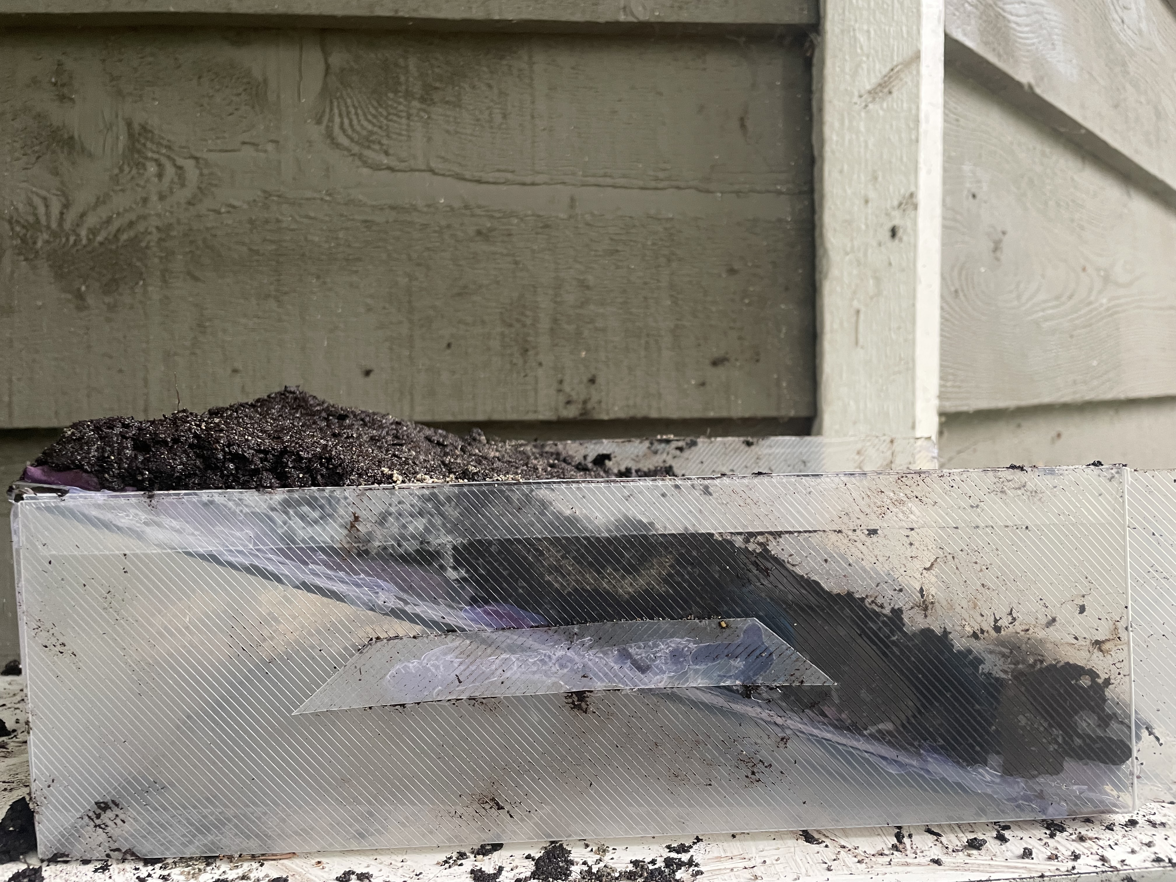
Figure 3: Side profile of test group #3 model
Modelling of the implementation of cross ditches (Test group #4)
BC Ministry of Forests Engineering Manual (2023) and Culvert BC (2002a) guidelines were used to model cross- ditches on an intact resource road (i.e no form of pullback) (Figure 4). Following modelling of the resource road previously outlined for test group #2, two ditches roughly 2.50 cm apart, 2.50 cm in width and slightly over 0.50 cm in depth were dug out at a 60° angle with the road edge. Ditch blocks made of Sta-Green 0.62 to 0.75-in River Stones were added to one side of each inlet. The same stones were also added at cross- ditch outlets to prevent erosion from water flow.
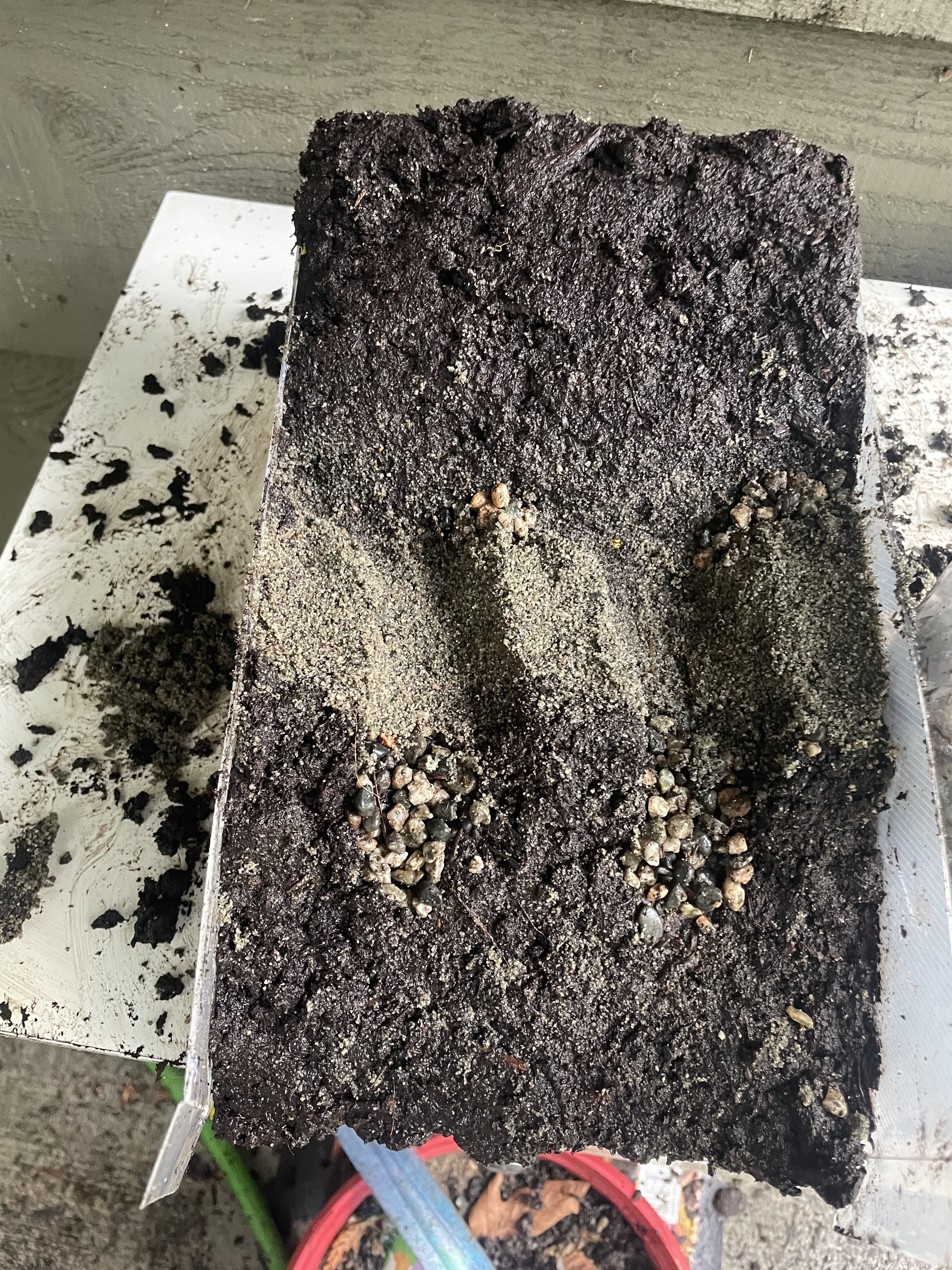
Figure 4: Front view of test group #4 model
Rainfall modelling
After reviewing Metro Vancouver Regional Intensity Duration Frequency Curves (2009) for Zone 7, where the majority of Vancouver’s local mountains are found, it was determined that 2.78 liters of water would be required to mimic a rainfall of 15 minutes with a 50-year return period (53.2 mm of rainfall over a 29.00x 17.00 cm surface area). A Buumin pressurized watering can was used, filled with 3 liters of water and pressurized, water was then released 15.00 cm above the top of the slope model for 15 minutes at 3-minute intervals to allow for repressurizing in between for a more consistent water pressure.
Data Collection
Models were placed at the edge of a step above a container so that water and debris runoff could be collected (Figure 5). Soil displaced off the end of the model and into the collection bin below was collected, strained through an Everyday Essentials Cheesecloth and weighed using a Starfrit digital kitchen scale.

Figure 5: Trial setup
Results
Results showed the greatest mass of soil was displaced in the positive control (test group #2) and the least soil displacement in the negative control group (test group #1). Additionally, less soil was displaced in test group #4 in comparison to test group #3, indicating that the implementation of cross ditches may be a more effective technique than full road fill pullback (Figure 6).
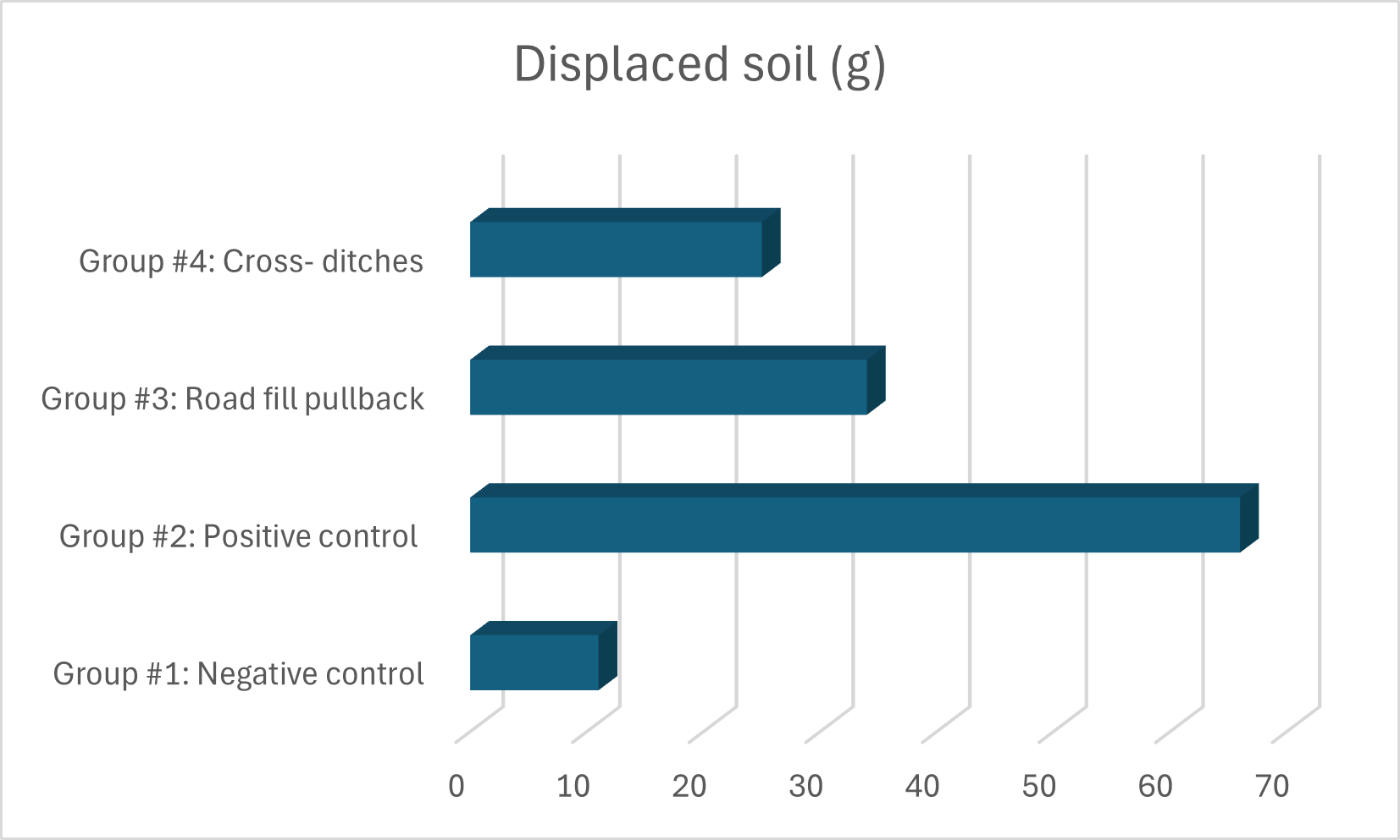
Figure 6: Mass of displaced soil (g) collected for each test group
Qualitative data was also collected. Photos of the front of the slope before and after simulated rainfall show movement of soil and road material where applicable (Figure 7- 10). Changes to the slope’s profile were also observed (Figure 11).
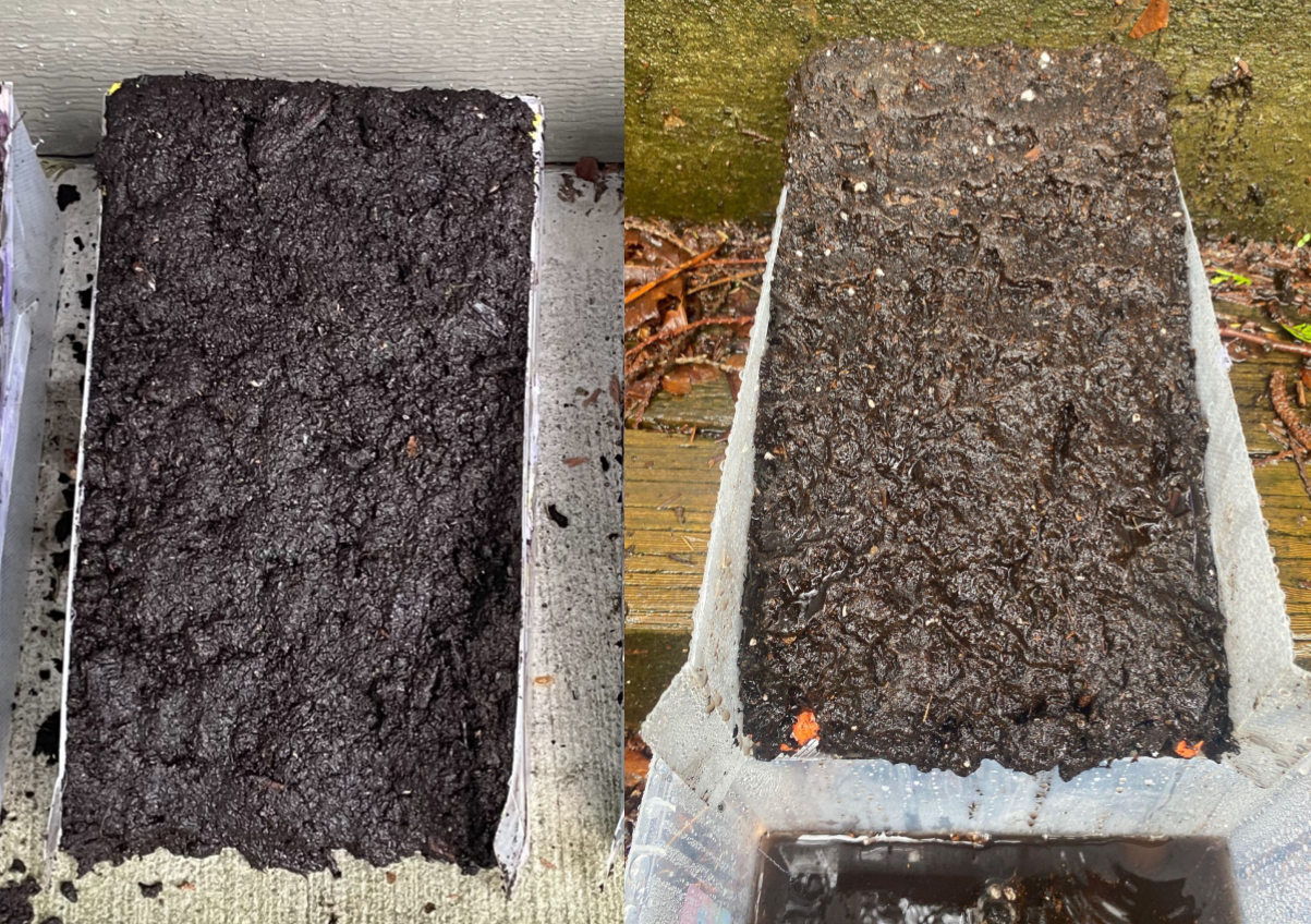
Figure 7: Before (a) and after (b) front views of test group #1 (negative control)

Figure 8: Before (a) and after (b) front views of test group #2 (positive control)

Figure 9: Before (a) and after (b) front views of test group #3 (full road fill pullback)

Figure 10: Before (a) and after (b) front views of test group #4 (cross ditches)
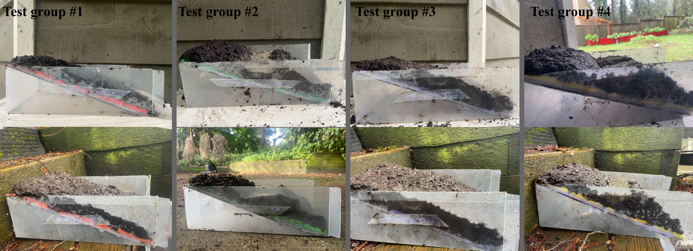
Figure 11: Slope profiles before (top row) and after (bottom row) testing
Discussion
Control groups
Ridging of the soil surface, bulging at the toe of the slope, and debris flow, were all qualitatively noted in greatest magnitude by test group #2 (Figure 8). Exposed modelling compound visible at base of the slope indicates bulging of soil at the foot of slope, as bulged up soil was allowed to fall and then collected. Additionally, runoff soil collected below the model was utilized as a quantitative measurement of displaced soil, also found to be largest for the positive control group. The negative control group (test group #1), which had an unaltered natural slope grade, and no resource road implemented, saw significantly low soil displacement.
Test groups 3 and 4: deactivation techniques
Both road deactivation techniques tested were found to successfully decrease risk of slope failure as they experienced less displacement of soil in comparison to the intact resource road (test group #1). Most visible soil displacement for test group #3 was found where road fill material existed below natural soil (Figure 9). It is likely that this took place due to the decreased water absorption in this area, resulting in a greater runoff. Test group #4 saw some degradation of the cross ditches, with their depth decreasing as road material was displaced into the ditches (Figure 10). While the ditch blocks successfully diverted water from the road ditch through the cross ditches, it is possible that the volume of water travelling down the ditches was too great for their size and caused such degradation. Thus, it may be favorable to increase the depth of the ditches as well as minimize overflow with the addition of a berm (Atkins et al., 2021). It was found that test group #3 experienced more soil displacement than test group #4. This is seen in the greater mass of collected soil for test group #3 as well as in the comparison of Figures 9 and 10, where there was more exposed modelling compound at the base of the slope for test group #3. This claim is also supported in the comparison of each slope’s profile (Figure 11), with test group #3 seeing a greater amount change in profile below the location of the resource road. Overall, findings suggest that the implementation of cross ditches is more successful in reducing landslide risk than full road fill pullback.
Alignment with industry
The displacement of soil where roadfill was present in test group #3 is in alignment with typical behavior in that the interruption of natural water flow and absorption by resource roads results in increased landslide risk (Borga et al., 2004). To combat this Culvert BC (2002b) recommends removal of all roadfill, as opposed to the method followed in this paper. However, the presented data does not perfectly align with other studies, as restoring the slope to its natural profile and surface material through full road fill pullback has been found to be favorable in terms of restored natural infiltration rate and as a reducing factor of surface runoff and erosion (Sosa-Pérez & MacDonald, 2017). However, the effectiveness of the implemented road deactivation techniques in comparison to the positive control group is supported by assessments done by Forest Practices Board (2017), which outline the importance of proper construction and deactivation of resource roads with respect to slope integrity and stability. As well, recommendations and regulations regarding resource roads deactivation in BC Ministry of Forests Engineering Manual (2023) are based on similar findings.
Limitations
There are many limitations to this paper, namely regarding the small scale of the slope and the materials chosen. Firstly, the model used was on a 1:100 scale meaning that the behavior recorded may not accurately represent that of a full-scale slope. This leads to errors in scaling of the rainfall, as the depth of the soil was not considered when determining the volume of water added due to the large variation of its depth in nature. Thus, the saturation of the model’s soil during the simulated rainfall is not entirely accurate in representing that of BC’s mountains. Furthermore, for the sake of simplicity and consistency between test groups, no vegetation was added to the slope models. Vegetation plays a key role in slope stability as does variations in soil across BC’s mountains and it is essential that further testing is done implementing these factors. Other factors may generate sources of error such as slight variations in water pressure as well as any uneven compaction of soil or road material across the test groups. For similar reasons of simplicity, an ideal resource road was modelled following dimensions from Dickerson et al. (2013) as well as one with a longitudinal slope grade near 0%. It is important to note that many resource roads do not follow the same guidelines and, while some sections of these roads have a similar, near 0%, longitudinal slope grade, much steeper grades can be found on BC’s resource roads. Both factors increase the instability of both the resource road and the slope it is constructed on and thus, tests performed in this paper cannot completely characterize all of BC’s resource roads. Finally, results could have been more reliable had multiple trials been performed.
Next Steps
It would be beneficial for the cost effectiveness of each technique to be studied in determining favorability of each technique. Testing integrity of slopes with storms of 100-year and 200-year return periods is also recommended, since it is likely that they will have a greater impact on slope stability. Additionally, further testing and research on both a larger scale and over a longer time period is necessary to better assess effectiveness and longevity of these deactivation techniques.
Conclusion
A key goal of this paper was to determine whether simple techniques, such as those tested, can be viable options for companies who build and must deactivate their resource roads. Models and tests were designed in the context of BC’s weather, topography, and road regulations. Testing saw both techniques showing successful ability to decrease landslide risk. Despite sources of error arising surrounding the accuracy of rainfall scaling, results align closely with industry knowledge and, thus, results provide valuable insight for resource road construction and management groups into the need for proper road deactivation. Future research should be aimed toward more accurate and likely larger scale models to provide more applicable information.
References
Atkins, R. J., Leslie M. R., Polster, D. F., Wise, M. P., & Wong, R. H. (2021). Best Management Practices Handbook: Road deactivation techniques. In BMP: Hillslope Restoration in British Columbia – Chapter 3. https://www2.gov.bc.ca/assets/gov/farming-natural-resources-and-industry/natural-resource-use/resource-roads/engineering-manual/78_road_deactivation_techniques.pdf
Borga, M., Tonelli, F., & Selleroni J. (2004). A physically based model of the effects of forest roads on slope stability. Water Resource Restoration. 40. W12202. doi:10.1029/2004WR003238.
Burton, B., BGC ENGINEERING INC., & Jakob, M. (2009). Climate Change (2050) Adjusted IDF curves: Metro Vancouver climate stations. https://www.portmoody.ca/en/business-and-development/resources/Documents/Metro-Vancouver-Climate-Change-2050-Adjusted-IDF-Curves—2009.pdf
Brend, Y., & Duncombe, L. (2022, October 27). Fatal landslide blamed on old logging road raises fears about hidden risks near Canada’s highways. Canadian Broadcasting Corporation. https://www.cbc.ca/news/canada/british-columbia/landslide-risk-service-roads-1.6628050
Culvert BC. (2002a). Forest road deactivation practices in the Pacific Northwest. 9 – Cross-Ditches (Road Intact). Flip Productions Limited. https://culvertbc.ca/fieldguide2/09.html
Culvert BC. (2002b). Forest road deactivation practices in the Pacific Northwest. 12 – Full Sidecast Pullback. Flip Productions Limited. https://culvertbc.ca/fieldguide2/12.html
Dickerson, A., Nicoll, B., & Perks, M. (2013). Forest road construction and timber transport. Forestry Commission. (ISBN 978-0-085538-891-1). https://cdn.forestresearch.gov.uk/2013/01/fctn020.pdf
Washington Suburban Sanitary Commission (2019). Pipeline Design Manual. WSSC. https://www.wsscwater.com/sites/default/files/sites/wssc/files/pipeline%20design/2019%20Pipeline%20design%20manual.pdf
Forest Practices Board. (2017). Resource road construction in steep terrain. In Special Investigation (FPB/SIR/47). https://www.bcfpb.ca/wp-content/uploads/2017/09/SIR47-Steep-Roads.pdf
Ministry of Forests. (2024, July 29). Resource roads – Province of British Columbia. https://www2.gov.bc.ca/gov/content/industry/natural-resource-use/resource-roads
Ministry of Forests. (2023). Engineering Manual: Chapter 7 – Road Deactivation. Province of British Columbia. https://www2.gov.bc.ca/assets/gov/farming-natural-resources-and-industry/natural-resource-use/resource-roads/engineering-manual/engineering_manual.pdf
Ministry of Forests. (2024, July 29). Resource roads – Province of British Columbia. https://www2.gov.bc.ca/gov/content/industry/natural-resource-use/resource-roads
Schwab, J. W., & Geertsema, M. BC Ministry of Forests and Range, & BC Ministry of Forests and Range. (2008). Terrain Stability Mapping On British Columbia Forest Lands: A Historical Perspective. https://cgs.ca/docs/geohazards/GeoHazards4/geohazard/alea/Schwab.pdf
Redd Fish Restoration Society (2023, February 8). Launch of ambitious landslide stabilization project with Hesquiaht First Nation. https://reddfish.org/press/hesquiaht-landslide-stabilization
Sosa-Pérez, G., & MacDonald, L. H. (2017). Effects of closed roads, traffic, and road decommissioning on infiltration and sediment production: A comparative study using rainfall simulations. CATENA, 159, 93-105. https://doi.org/10.1016/j.catena.2017.08.004
Westrek Geotechnical Services Ltd (2024, August 28). What factors make British Columbia vulnerable to geohazards? . https://www.westrekgeotech.com/what-factors-make-british-columbia-vulnerable-to-geohazards/
Jing, X., Chen, Y., Pan, C., Yin, T., Wang, W., & Fan, X. (2019). Erosion Failure of a Soil Slope by Heavy Rain: Laboratory Investigation and Modified GA Model of Soil Slope Failure. International Journal of Environmental Research and Public Health, 16(6), 1075. https://doi.org/10.3390/ijerph16061075
Zhang, Yanqi & Ding, Jiajia. (2019). Stability Analysis of Slopes on Both Sides of Highway in Geotechnical Area under Rainfall Conditions. IOP Conference Series: Earth and Environmental Science. 384. 012076. https://doi.org/10.1088/1755-1315/384/1/012076